

MRAUK U Map
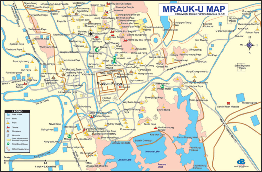
Mrauk U Map
To download full and complete Mrauk U Map
1.Press Download
2.Complete the form and press submit.
3.you will recieve the download clink via email to the email address you have provided

Mrauk U Map Download
Download procedure
1. Click "Download" button.

2. Fill the Download form correctly, (notic: email must be correct) click "submit" button and download link will sent into your email soon.

3. Check your email and you can get myanmar map via the link.
Union of Myanmar
Ministry of Culture Department of Archaeology
A Brief Presentation of Cultural Heritage Sites in Rakhine State
Location of Rakhine State
Rakhine State is located in the western part of Myanmar. The area of Rakhine State measures 14200 square miles. The length of Rakhine State from North to South is 360 miles . Rakhine Yoma mountain ranges lie in the east and the Bay of Bengal is in the west.
Historical periods of Rakhine States.
There are four historical periods in Rakhine State namely (1) Dhanyawadi period (2) Wethali (Vesali) period (3) Lemyo period and (4) Mrauk - U period.
(1) Dhanyawadi period.
According to Rakhine chronicles the first Dhanyawadi dynasty was founded by King Marayu in 3000 BC. Fifty four kings ruled over Dhanyawadi for 1816 years in three places called Kan - thone sint, Nilar Pantaung and Kyauk - pan - taung. The first Dhanyawadi period was from 3000 to 1508 BC.
The second Dhanyawadi dynasty was founded by King Kanyarzargyi in 1507 BC. Twenty eight kings ruled over Dhanyawadi for 927 years . The king Dhanyawadi period was from I L~07 to 580 BC.
The third Dhanyawadi period was founded by King Sanda Thuriya in 580 BC. King- Bheimbitharya Was a contemporary king who ruled over Maghada Kingdom in India. The third Dhanyawadi dynasty was started with King Sanda Thuriya 580 BC and ended with King Thuriya-- ketu AD 326.
Evidences of Cultural Heritage.
(a) City - Walls
The remains of the third Dhanyawadi city - walls and palace enclosure walls can clearly be seen in the aerial photo. The elongated mounds of the third Dhanyawadi city walls are lying at the front of Thari - choung about 6 miles to the east of present Kyauk taw town ( 93 113' - E. Long 20 H- 52' N. Lat : )
The third Dhanyawadi ancient city was irregular circular in shape . It measures 1.3 miles from east to west and 1.55 miles from north to south. The palace site and the square palace enclosure wall is located in the middle of the city wall. The palace enclosure walls measure 2000 feet from east to west and 1700 feet from north to south.
(b) Maharmuni Shrine
Maharmuni Shrine is located on a small hill at the north east of the palace site. Maharmuni Shrine was built to house the Maharmuni bronze Buddha image.
According to Rakhine chronicles. Maharmuni broze Buddha image was said to be cast at the time of King Sanda Thuriya in BC 554. This Buddha image was said to be the replica of Gautama Buddha which was cast by King Sanda Thuriya during the visit of the Buddha to Selargiri hill near Dhanyawadi city.
One of the most important stone sculptures found at Selagiri mountain is the sculpture of Buddha in preaching posture with a disciple sitting beside him. The figure of sitting disciple in that sculpture is believed to be that of King Sanda Thuriya. This sculpture is assignable to 6th century AD.
Another important sculpture found on Selargiri mountain is the sculpture of the Buddha In (maha -parinivana) dying posture . Below the figure of the Buddha, the figures of three mourning disciples can be seen. The other interesting sculpture is the sculpture of Buddha preaching six devotees.
(c) Stone sculptures on Maharmuni Hill.
MMany sculptures are found on the Mahamuni hill. These sculptures can be identified as the sculpture of Yaksa - Senapati Panada, Lokapala, Naga and Nagi, and Bodhisattava. These sculptures are dateable to 5t" century AD on the basis of the study of their iconography.
(2) Wethali (Vesali) Period
According to Ananda Sandra inscription recorded in AD 729 three dynasties ruled over Wethali Kingdom from 510 BC to AD 720 . Altogether 36 kings ruled at Wethali Kingdom . The first Wethali dynasty was founded in 510 BC and ended in the time of King Linki in AD 370 . The name of the first king is unreadable . There were fourteen kings in the first Wethali dynasty .
However thirteen kings ruled for 230 years in the second Wethali dynasty starting from Dwen (who ascended the throne in AD 370 and the second Wethali dynasty ended with Sariti Sandra in AD 600 The third Wethali dynasty was founded by King Maha Vira in AD 600 and ended with the reign of King Anatha-wa-thaya in AD 720 according to Ananda Sandra inscription. However, Rakhine chronicles mentioned that Wethali Kingdom was founded by King Maha Sandra in AD 327 and twelve kings ruled over Wethali kingdom. Wethali dynasty ended at the time of the last King Ngatone, son of Sula- Sandra in AD 794 According to Rakhine chronicle splendid Wethali city was founded by King Maha Sandra or Dven - Sandra in AD 327.
Wethali (Vesali) the ancient city.
The remains of the Wethali city walls and buildings in the form of earth mounds are still visible about 6 miles north of Mrauk- U town . Wethali city (93 H- 9' E . Longitude and 20 H- 40' N - Lattitude ) is irregular circular in shape measuring 1.7 miles from north to south and 1.2 miles from east to west.
Wethali walled city is about 2.7 square miles in cicumference and the city walls were built of large - sized bricks. It was found that the city walls were surrounded by a deep moat which was now already dried and silted with earth and mud. The city was built near a large stream called Randawadi or Ran - chaung.
Wethali stream a tributory stream of Randawadi flows across Wethali city providing sufficient water for cultivation . The palace buildings surrounded by palace walls were located in the centre of the city . Now the remains of the palace buildings can be seen in the form of flat mounds inside modern Wethali village.
The excavations at Wethali (Vesali)
Archaeological excavations were conducted at Wethali ancient city for five seasons starting from 1979 - 1980 financial year to 1983 – 1984.The excavation team excavated five mounds inside Wethali walled-city. The aim of archaeological excavations is to find out the historical facts and archaeological evidences of Wethali period which once had been a golden age in Rakhine history. Altogether five mounds were excavated at five prominent sites.
Excavation at Mound No 1.
Mound No 1. is located in the middle of Pauk- taw - pyin village. It is a small mound about 6 feet high from the ground level. The excavation revealed a brick building measuring 64'- 6" in length and 48' in breadth.
The excavation team could excavate only half of the mound because of the existence of a few houses on the mound . A stone drainage pipe and a broken stone pedestal of Buddha image were found during the excavation. This brick building consists of some rooms.It is believed to be a monastery for Buddhist monks.
Excavation at Mound No. 2.
Mound No 2 is located 150 yards to the south of Wethali village. That site is in the center of Wethali ancient city. The mound measures 165 feet from east to west and 150 feet from north to south. The height is about 18 feet.
Excavation at mound No 2 was started in 1980. Excavation revealed a square brick building which was fenced by brick enclosure wall. The enclosure wall was built about 32 feet away from the main building. The enclosure wall measures 163 feet in the east, 162 feet in the west, 164 feet in the south and 165 feet in the north. The thickness of the wall is 7.5 feet. The brick building inside measures 85 feet from north to south and 60 feet from east to west. In the north of the building extension brick walls were found which were probably a corridored passage way. A square brick platform with three receding steps was built in the middle of the building. The lowest platform measures 14'-6" in four sides and the height is 2 feet. The middle platform measures 13'-6" in each side and 3'-6 " high. The upper platform measures 10'-6" at each side. However except the western side, the other sides have all collapsed. The upper platform is about 4'-6" high. Oil top of the platform a square stone slab measuring 2 feet at each side was found. The stone slab has a hole in the middle. It is supposed to be a base stone on which a stone stupa was placed. Therefore this building was supposed to be a religious building where the religious ceremonies were usually held. It is noteworthy to mention about the finding of a terra- cotta votive tablet near the northern wall of the building at the depth of 8' feet. The small votive tablet measures 2.6 "inches high and the breadth is 1.7 inches. Buddha figure is in sitting posture with the legs hanging from the throne. Boddhisattva figures can be found on either side of Buddha figure.
Excavation at Mound No. 3
Mound No. 3 is located about 50 yards to the north of Mound No.2. No structural remain was found at Mound No.3 . Excavation brought to light a stone sculpture of a bull. The front part of the stone sculpture was missing. Only the hind part of the bull stone sculpture was found. The stone sculpture measures 31 inches in length, 26 inches in breadth and 16 inches in height.
Excavation at Mound No. 4
This site is located about 50 yards from Pauk - taw – pyin village. The location of the site is on the south - eastern part of Wethali city wall. The aim of excavation at Mound No. 4 is to study the method of construction and height and thickness of the city wall. Long trench system was used and dug upto natural soil . It was found that Wethali city wall is 14 feet in thickness, the remaining city wall is about 8 feet high . Judging by the heap of debris the original height of the city - wall will be 15 feet high . The size of the brick used in the lower part of the city wall is larger than the size of the brick used in upper walls.
An incribed stone slab measuring 6" x 10" was found at the excavation site. The stone slab bears the record of donation by a king of Wethali period probably King Nitisandra.
Excavation at Mound No. 5
Mound No. 5 is located in the northern part of Pauk - taw - pyin village The mound before excavation was 75 feet from east to west, 90 feet from north to south and 4 feet high. Excavation revealed an ordination building built of bricks. It is square in shape measuring 74 feet from north to south and 50 feet from east to west. The entrance to the building is in the east. This building consists of an ordination hall and a small room. Altogether 13 sima stones of patrified wood were found around the brick ordination building.
(3) Lemro Period
Wethali (Vesali) period was followed by Lemro period.When Wethali (Vesali) city was ruined in AD-794, Rakhine people moved from Wethali to Lemro delta region where they founded a new city Pyinsar. Lemro period was started from AD-818, and ended in AD-1430. Altogether four cities were built in Lemro delta region such as Pyinsar, Purain, Cheik, and Laung-kyet. Lemro kings built one city after another and ruled for 600 years. Because of the changes of the river course and erosion, all the city walls and structural remains were no more in existence. Besides, religious buildings and palatial buidings were destroyed and wiped out by river erosion. Therefore substantial structural remains of Lemro period were. all lost from our sight. A few remaining stupas were also renovated or rebuilt in modern times.
Pyinsar City (AD 818—AD 1103)
Pyinsar city was founded by King Khitta-thin in AD 818 who was the grandson of King Sula Sandra, the last king of Wethali dynasty. That city lasted for 285 years and fifteen kings ruled at that city upto AD 1103.
First Purain City (AD 1103—AD 1123)
King Letyar Minnan ascended the throne of Pyinsar Kingdom in AD 1103 with the assistence of king Alaung-sithu of Bagan. After ascending the throne, he founded a new city Laung-Kyet. Since bad omen and misfortune fell on the city of Laung-Kyet, the king founded another new city Purain and six kings ruled for twenty years upto the reign of King Kawliya AD 1123.
Second Purain City (AD 1123—AD 1142)
King Dathayarzar son of King Kawliya founded the second Purain city in AD 1123 which is located about four miles to the south-east of modern Mrauk-U town. Again in AD 1142,''King Min Phone Sar moved the capital city from Purain to Khreik. Three kings ruled at Khreik from AD 1142 to AD 1154 for twelve years. Moreover, Rakhine chronicles mentioned that King Dhana-Rupal founded Sambawet city in AD 1158 and prince Myinzu-thin founded Narinsayar city in AD 1163. Seventeen kings ruled for eighty-eight years.
Laung-Kyet City (AD 1251—AD 1406)
King Alaw-mar phyu who ascended the throne in AD 1250 moved the capital city from Narinsayar to Laung-kyet on the other side of Lemro river. Eighteen kings starting from King Alawmar-phyu to King Min Saw Mon ruled at Laung-kyet city for 155 years. In AD 1406 King Min Ye Kyaw~ Swar of Inwa (Ava) Kingdom attacked Laung-kyet city. Therefore King Min Saw Mon fled to Bengal and stayed there for twenty two years. King Min-Htee is the longest-living and the most prominent king who ruled at Laung-kyet city.
Laung-kyet Toung Maw Inscription
Laung-kyet hill is located five miles to the east of Mrauk-U town. In AD 1123 King Kawliya recorded about his meritorious deeds by inscribing on the surface of natural rocks. The large rock measures 65 feet in length, 20 feet in height and 4 feet in thickness. In this inscription king Kawliya mentioned about the objects which he donated such as mats, pots, slaves; etc. The king also mentioned about his restoration works of ruined monasteries and construction of 7760 Buddhist stupas. He proclaimed himself as an incompareable donor who is very generous in donating.
Although Lemro period (AD 818—AD 1430) cultural heritage monuments are not in existence nowadays, a considerable number of bronze Buddha images were collected by the Department of Archaeology from the ruined stupas since pre-war days. These collection of ie miro"p&*iod Buddha images in various mudras are displayed in the Mrauk-U Archaeological Museum.
Cultural Heritage Monuments at Mrauk-U Historic City
Location
Mrauk- U historic city (20-25 N.Lat -93-11 E Long) is situated 40 miles to the north-east of Sittwe the capital city of Rakhine State in the western part of Myanmar. Mrauk - U ancient city was fortified by 30 Kilometer long fortification stone walls. In some parts stone fortification walls were connected with natural mountain ranges. These long fortification walls were surrounded with moats and canals. In some places natural ponds and lakes were used as natural barriers for the city. Mrauk-U is easily accessble by boat or by car from Sittwe. It takes about less than two hours by speed-boat, about four hours by normal boat and about five hours by car from Sittwe.
Mrauk-U ancient city was located inside the elongated mountain ranges. Apart from natural mountain ranges, massive stone fortification walls were built to defend from the danger of military campaign from their rival Kingdoms. The view of Mrauk-U city as seen from above with the surrounding mountain ranges and encircling canals and moats makes the visitors spellbound. Mrauk-U city can be said as the strongest fortress city built in 1511, century A.D as evidenced by the remains of massive stone fortification walls and gate ways.
Mrauk - U which remained as the capital of Rakhine Kingdom, was founded by King Min Saw Mori in AD 1430 . There were three Mrauk- U dynastic period. First Mrauk - U dynasty started with Min Saw Mon ( AD 1430-1433 ) and ended with Min Khaung Razar (AD 1521-1531 ). Twelve Kings ruled over the First Mrauk - U dynastic period. The Second Mrauk - U dynasty was started with King Min Bar Gyi (AD 1531-1553 ) and ended with King Min Sanai ( AD 1638, 20 days) . Nine Kings of the Second Mrauk - U dynasty ruled at Mrauk - U Kingdom. The third or the last Mrauk - U dynasty was ruled by twenty-seven Kings starting from King Kuthala - Narapatigyi ( AD 1638-1645 ) to King Mahathamada Razar ( AD 1782-1784 ) Altogether 48 Kings ruled over Mrauk - U Kingdom for 354 years.
Golden Mrauk – U
King Min Saw Mull founded Mrauk - U in A.D 1430. To make it last long for future generations he even risked his life. Against the counsel of Brahman astrologers and sages who predicted that " if His Majesty attemped to build Mrauk - U, the capital would last long but His Majesty's life be shortended", Min Saw Mun was unshaken in accomplishing his ambition. One of his sussessors King Min Bar Gyi (A.D 1531 - 1553) further strengthened, extended and modernized Mrauk - U . Diplomatic relations with Portugal and Holland were opend and trade with the Portuguese the Dutch and the Spanish prospered. Foreign visitors of that time remarked in their account that "Mrauk - U is like Amsterdam and London, one of the rich and thriving commercial seaport cities in South - east Asia."
King Min Bar Gyi was a very cautious king who paid special attention to the security and defence of his Kingdom. Ancient city Mrauk - U, as it stands to day testifies to it. He could assess and utilize for defence purpose the strengths and weaknesses of the geographical location and natural environment of his domains. As the Kingdom occupied a narrow coastal strip with the sea front and being Criss- crossed by several rivers and streams, these physical features were put to use for building security and defence. Most ancient cities in Myanmar have normally three kinds of moat, Shunt Kyon, Nyun Kyon and Kyon Chauk defending them. But in the case of MraukU*, there were two more moats namely Kyon Shin and Kyon Pinlei, in addition to the usual three. So Mrauk - U was unique in defence system for it was defended with 5 moats. Mrauk - U is situated within the sea coast. It is surrounded by natural water system. Rivers and streams are fed and activated by the ebb and flow of the tide. For defence purpose, some of natural waters were drained off and land- filled, some were widened and extended yet some were deepened so that water flow could be regulated to form Kyon Shin to obstruct the invaders.
The unique characteristics of the topography of Mrauk - U is that tiers of hills and mountains running around it. Between them are natural passes through which access is easy. These natural passes were fenced with earthen walls and stone walls thus forming a long line of defence walls aligned with hills and mountains. Between hills and mountains where it was locationally favourable, big dams and reservoirs were built to store water as well as to serve as water barrier (Kyon Pinlei). Water gates and sluices were installed systematically so that water could be regulated to supply for public consumption and to rush it out to repulse the invaders. Even to - day Mrauk - U municipality enjoys the benefit of the water storage syatem of old days. We cannot help but utter words of admiration and appreciation and express thanks to King Minbin of golden period of Mrauk - U for his farsightedness and ingenuity in town planning and defence system for future generations to enjoy welfare and security.
All along the hills and mountain ranges where there were strategic points and main entries and exists of rivers and streams, were built fortresses into the natural surrounding. At present " Kyaung Lei Don" Fortress of stone in its original condition can be witnessed to the north - east of " Ko Thaung Pahto Daw Gyi Pagoda". King Minbin who made security and defence top priority in his national policy even turned to occult science for reassurance. Two of his guru monks Venerable Shin Mya Wa and Venerable Maha Pyannyar Kyaw who were expert in vedas, astrology, charm and cabalistic diagram were consulted. Under their instruction and supervision , a hundred large fences and a thousand small fences with cabalistic diagrams affixed to them were installed on the summits of hill and mountains ranges around Mrauk - U. These mystic fences the two monks arranged were believed to have potent supernatural power to ward off the enemies. Many caves and pagodas were built near them.
After the security and defence system was established naturally, artificially and supernaturally, King Minbin did his best in food storage for his subjects in normal time as well as in emergency. Special sites were chosen to build granaries. Historical records tell us that there were 41 big granaries at Mrauk - U alone.
Right now archaeologists have discovered and compiled an inventory of 13 granaries. It is expected more will be found. Of the 13 granaries, Win Ma Na Granary is now being preserved by Archaeology Department, Mrauk - U Branch.
City gates that provided entry into the city were built in accordance with their strategic importance. They are strong gates built of stone. Water gates and sluices built of the same material are in good condition till to - day. Contemporary of Kings Tabin Shwe Hti and Bayint Naung of Taungoo and Hamsavadi respectively, King Minbin ranked equal to them in that he provided strong security and defence, and sufficient food storage to his people. His Kingdom was a modern and developed Kingdom of that time. He left strong united, consolidated prosperous and progressive Kingdom for generation of 48 successor kings after him who ruled and regined for 354 Years. Mrauk - U is the only site in Myanmar where there is as assemblage of many stone buildings.
A model of Mrauk - U with detail of its natural and man - made barriers and defence walls, city walls, moats, city gates, water gates, granaries, ets will be displayed for public at Mrauk - U Archaeological Museum so as to stimulate interest of local and foreign visitors.
Fortresses
Fortresses were built on the city walls of Mrauk - U . They were built of stone blocks on the mountain ranges in alignment with natural features of the ranges. Within the fortresses, there were flights of stone steps for the warriors to come up .
When enemies approached, all defence forces could be immediately alerted by pulling the chains attached to the bells to ring. These bells were installed hidden in the mouths of big lion statues.
Fortresses that survive till today are
Kyons (Moats)
Kyons or Moats are a kind of barrier to prevent access of enemies.There are five types of Kyon namely
Kyon Shin (2) Shunt Kyon (3) Nyun Kyon (4) Kyon Chauk and (5) Kyon Pinlei
1.Kyon Shin
Using the ebb and flow of tide, water is let in through canals and channels to run around the palace city. Or water is stored up in big reservoirs and in the event of enemies approach water gates and sluices are flung open to let water rush in. Canals and channels Criss - crossing Mrauk - U today are Kyon Shin constructed by Rakhine Kings of the past.
2.Shunt Kyon
Shunt kyons are beds of boggy and sticky mud of knee depth specially made so that no one could walk across them. Shut Kyons were made within the city walls.
3.Nyun Kyon
They are beds of mud of human height's depth which no one could pass through. Nyun Kyons were also situated within the city walls.
4. Kyon Chauk
They are dry moats with no water but in them were installed iron spikes, traps, thorns, stone blocks and barriers etc. Kyon Chauks are located outside ~the city walls.
5.Kyon Pinlei
Like a sea, the entire moat is filled with water to the brim or large reservoirs full of water.Their large extent of water looks like a sea. Kyon Pinlei were built outside the city walls.
In addition to the Palace enclosure walls and city walls there are 28 Kyon Pinlei [moats] around the city walls. They are: (1) Yey Pauk Wa Kyon [outside the Palace) and 12 Kyons outside the Palace walls are: (1) Let Sei Kan Kyon (2) Anu Ma Kyon (3) Pon Na Myaung Kyon (4) Kathahpa Kyon (5) 1- Win Kyon (6) Phone Gyi Don Kyon (7) Nga Mann Doll Kyon (8) Mee Tha Mar Kyon (9) Kywe Tin Htein Kyon (10) Ye Hla Kyon (11) Nat Don Kyon and (12) Pan Zey Myauk Kyon .
15 Kyons outside the city walls are
City walls
Mrauk U Palace was defended by three city walls.
Palace enclosure walls
(1) Let Sei Kan wall (south side) (2) Anuma wall (south side) (3) Nga Chauk Zey wall (west side) (4) War Zey wall (west side) (5) Yathey Taung wall (west side) (6) Pein Hne Taung wall (west side) (7) Min Tha Kyun wall ( west side) (8) Yey Tagar wall (west side ) (9) Shan Taung wall (north side) (10) Chin Kite wall (north side) (11) Min Tha Mee Myaung wall (North side) (12) Thet Ku Mann Aung wall (east side) (13) I-Win wall (east side) (14) Nga Mann Don wall (east side) (15) Ye Hla wall (east side) (16) Mee Tha Mar wall (east side) (17) Win Ma Nar wall (east side) and (18) Min Tayar Pyin wall (east side).
These walls in straight line measure 2 miles from east to west 2 miles from north to south long and 15 feet in width and over 20 feet in height.
Inside the palace walls were dwellings of queens, ministers, knights, counsellers, monasteries and pagodas and other religious edifices.
City Walls
Outside the palace enclosure walls there were 17 surrounding towns which were defended with city walls. Within these 17 towns resided princes, princesses, royal children, wealthy men, men of high rank and high social status. Royal princesses lived in Ta-bin Taing Palace near Mingalar Mann Aung Pagoda and royal princes lived in palaces on the Mintha Gyi Kon hillock on the upper reaches of Pan Zey Myaung canal.
There were 13 city walls namely:
Most city walls were built of stone and they run about five miles from east to west and about five miles from north to south.
Outer town walls
There were outer walls surrounding the city walls. Between the outer and inner walls dwelt the grassroot people who earned their living by cultivating, woodcutting, fishing and hunting.
It is known that there were 13 outer town walls and they were: Hlaing Saya outpost wall ( east side) Taung Myint Moe wall ( east side) Ma Kya Taung Tan wall ( east side) Kyaung Lei Don wall ( east side ) Chaung Thit wall ( east side ) Pipin Kon wall ( east side ) Hsin Oh wall ( east side ) Khaung Hpyu Taung wall ( east side) Moe Gyo Pyin wall ( east side ) Dah Kyo Thamar wall ( west side ) Let kauk zey wall ( west side ) Taung Hpyu wall (north side ) Tabin Taing wall (north side ) These walls were mostly natural hill range and mach made earthern walls combined
Big granaries
Kyi (granary ) is a storage in which grain ( especially paddy ) was kept for the consumption of King , royalties , courtiers , armed forces and public . It is said that in days of yore there were 41 granaries. Now only 13 granaries have been traced and identified . Among the 13 granaries, Win Ma-nar royal granary is the largest and best in architecture . Granaries are 5~0`rrounded by stone walls within which there is a small moat and one gate. On the wall is a small library where Tipitaka
[ Buddhist scriptures ] were kept. The 13 granaries located and identified are:
Paddy Sale Centres
There were 8 paddy sale centres They were:
Gates
Gates are of two types (1) Gates for the public access and (2) Gates for the access of water.There were 30 City Gates and 32 Water Gates. But to day's inventory includes over 20 Gates most of which are located at the city walls and palace enclosure walls They are:
Historic Buddhist Monuments around Maruk – U
Shit thoung Temple
Shit thoung is the most famous temple built by King Min Bar Gyi in AD 1535.This temple was built on the west side of Phokhoung hillock which is about 90 feet high. Shit-thoung main Ceti and surrounding small ceties were built on massive stone platform which is 12 feet high. The main image hall is at the centre of the shrine. The main ceti is surrounded by twenty-six smaller ceties. Shitthoung temple is 160 feet in length 124 in breadth and 86 feet in height. There are three passage ways inside the temple. The inner-most passage way is accessable from the second inner passage way. Stone Buddha images are placed inside the niches along the inner most passage way. Besides, the previous lives of the Buddha are depicted in the form of birds, animals and Jataka stories. The total number of stone figures in relief is more than: one thousand. Moreover, the stone figures of Indra, Brahma devas, Kings, Wasonederay, Kanneras are also found inside the temple, This temple is called Shitthoung Temple meaning more than 80000 Buddha images and relics were enshrined in this temple. Among the stone carvings the most interesting carvings'' are the figures of dancing, wrestling and practising martial arts.
Htokekant Theim Temple
Htoke kant Theim temple was built by King Min Phaloung in 1571 AD. It is located about 200 yards to the west of Shit-thoung temple. A small mound was levelled to about 20 feet and Htokekant Theim was built on it. One can reach to Htoke-kant Theim by ascending eighteen steps of stone stairs. Htokekant Theim is in fact an ordination hall (Sima) which was surmounted by a large stupa and surrounded by four small corner stupas. The plan of Htake-kant Theim resembles that of Shitthoung temple. The lower structure (the main temple) which is 110 feet from north to south and 137 feet from east to west, was built of stone while the upper main stupa and corner stupas were built of bricks. The western side of the ordination hall is circular in shape. (see plan) A Sabbath hall is attached to the ordination hall at south-western side. The height from floor level to the top of the stupa is 64 feet. There are many stone Buddha images inside the niches along the interior passage way of Htoke kant Theim temple. Many stone carvings of worshipping couples, royal families, and ministers were also depicted on both side of the niches. The stone carvings inside this temple are historically important because the visitors can study ancient MuaukU period costumes, ornaments and hair-knotting style and ladies headdresses.
Ratanapon Ceti
Ratanapon ceti was built by King Min Khamoung and queen Shin Htwe in AD 1612.The bell-shaped dome is resting on three receding terraces. The circumference of the bell-shaped dome is 344 feet and the height of the ceti is(100)feet. The upper portion above the bell-shaped dome was ruined and fallen down. Because of the falling of stones a large cavity appeared on the bell-shaped dome. This ceti was left in ruinous state for many years. In 1998, the Department of Archaeology replaced the missing stone slabs in the bell-shaped dome and reconstructed in its original design. It was a very large stupa constructed during the golden age of Mrauk-U period.
Linpan-pyauk Ceti
Linpan-pyauk Ceti was an octagonal stone stupa built by King Min Khaung Razar in AD 1525. There are sixteen niches to enshrine the Buddha images around the base of Linpan-pyauk Ceti. These niches are elaborately decorated with stone carvings of floral designs. This ceti was built on square platform which was beautifully decorated with colorful glazed floral motifs. Originally there were sixty large glazed flower designs in blue, green, yellow, white colors,--- on each side of the stone platform. This ceti is said to be built by the king to ward off the ill omen. It is accessable to the platform of the ceti by a stone stair case built at each side except the east which has two stair-cases.
Shwe-Kyar-Theim Ceti
This is a stone ceti built in the year AD 1471 by a royal princess called Saw Shwe Kyar the daughter of King Ba Saw Phyu and western-Queen. Princes Saw Shwe Kyar built a stone ceti and an ordination hall at the site of her residence where she resided during her childhood. That stone ceti has extraordinary architectural design. In the place of cylindrical bell-shaped dome, the dome of Shwe Kyar Theim was built in the shape of a Sikhara. The corner of square Sikhara has right-angle turns. So it looks very peculiar .
Antaw-Theim Temple
Antaw-Theim temple is located about 100 feet to the north of Shitthoung temple. King Min Bar-gyi, when he was a governor of Thantwe built a Ceti at Thantwe by enshrining a tooth-relic from Sri-Lanka. The tooth relic was given to him by a Buddhist monk who returned from Sri-Lanka. When he ascended the throne in Mrauk-U kingdom; King Min Bar Gyi built a stone stupa and brought the tooth-relic from the relic chamber of the said Ceti in Thantwe. The Ceti on top of Antaw-Theim is octagonal in shape which was surrounded by eight small stupas. There are two circum-ambulatory passage ways inside the temple. All along the passage ways, there are 175 niches where 175 stone Buddha images were placed for worship.
hin-Kike Pitakat-tike
This was an ancient pitakat library building to house the palm-leaf manuscripts of tri-pitakat text. It was built by King Min Phalaung in AD 1591. This pitakat-tike (library) was used by the monks and novices of Taung-nyo monastery nearby. This building was located near the Chin-Kike city gate of Mrauk-U city. So it was named as Chin-Kike pitakat-tike after the name of the city gate. It was a model building where the unique designs of stone carvings of Mrauk-U period can be abserved. It is amazing to see the very fine stone carving works of various types of floral designs at this building.
Le-myet-nhar Temple
Le-myet-nhar temple is a temple which has four entrances. It was built by King Min Saw Mon in AD 1430. The sanctum or the centre pillar is octagonal in shape. Eight niches were made to enshrine the eight stone Buddha images. Circumambulatory passage way was built inside the temple. Traditional arch -system was used in constructing this temple. This is a simple typed temple built of stone. Architectural design is not so complicated like Shit- thoung temple. A stone stupa was built on the octagonal main shrine hall. The height of the temple is about (45) feet.
Koe - thount: Pahto - taw - gyi
Koe - thoung Pahto - taw - gyi was built by King Min Teik - Khar in AD 1553. Originally there was a stone stupa in the centre of the square stone platform. The stone stair - way which has (9) steps was about 15 feet wide. The stone tair - way was built on the eastern side. On the other three sides three rows of small stupas were built on three receding terraces. One side of the store platform measures (250) feet. All the small stupas and center stupa cokapsed due to bombing during the Second World War. Vaulted arched-wa, was constructed around the square platform . On the stone walls of the aroned-way were stone carvings of numerous Buddha images
Starting from 1997, Department of Archaeology carried out necessary measures of conservation and restoration. First stone blocks and debris were removed from the arched-ways. Receding terraces were rebuilt and three rows of small stupas were reconstructed on the southern and eastern sides.The stupa in the center of the square platform has also been under reconstruction
Mrauk-U Royal Palace
Mrauk-U royal palace was built in the centre of Mrauk-U fortified city. The first palace was built of bricks by King Min Saw Mon in AD 1430 and the old palace was rebuilt in stones by King Min Bar Gyi in AD 1531 . At that time moats and canals were dug around the city. The palace platforms were built of stones. There were three palace enclosure walls which were divided by massive stone walls. The inner or the first enclosure wall measures 656 feet from east to west and 879 feet from north to Borth. The royal palace building was built on the inner palace platform. The second enclosure wall measures 926 feet from east to west and 859 feet from, north to south. The outer or the third enclosure wall measures 1740 feet from east to west and 1606 feet from north to south. Today the height of the stone wail measures Q feet and the thickness is 7 feet. Department of Archaeology carried out of excavations in three reasons 1996, 1997 and 1999. The first season of excavation revealed the stone walls of the palace building and a stone stair with seven steps. The length of the stone stair measures 18 feet. Excavations were conducted inside the inner enclosure walls. The grand royal palace building was built inside the inner enclosure walls. The stone walls which divided the royal palace buildings were unearthed by excavation. According to the contemporary records it was learnt that Mrauk-U royal palace has five tiers of roofs built on big and straight teak posts which were z] gilded. The roof was also plated with gold.
Mrauk-U Archaeological Museum
Mrauk-U Archaeological Museum is located inside the compound of Mrauk-U royal palace. This small museum building which was built in 1967 has already been renovated during the last quarter of the year 2002. The museum consists of five main exhibition rooms such as stone inscription exhibition room, Buddha images exhibition room, art objects exhibition room, glazed ware and ceramic exhibition room, and model of Mrauk-U ancient city exhibition room. The exhibits in the museum belong to Dhanyawadi period, Vesali period, Le-Myo period and Mrauk-U period. These museum pieces are selected pieces of respective historical period. Among the museum exhibits, there are (47) stone inscriptions, (10) stone Buddha images, (52) bronze Buddha images and (6) iron cannons. The collection of glazed wares in the museum is also of great interest for the visitors.
Conservation and Restoration of Cultural Heritage at Mrauk-U
Mrauk-U Kingdom was founded by King Min Saw Mon in AD 1430 . Forty eight kings ruled over Mrauk-U Kingdom for 354 years.The golden age of Mrauk-U came to an end in AD 1784 at the time of King Maha-thar-nataRazar. Pious Buddhist Kings starting from King Min Saw Mon, royal queens, ministers and royal families built many stupas and temples around Nlr.-ILII -U Kingdom. The inventory list of ancient Buddist edifices shows that there are 157 ancient religious monuments around Mrauk-U. Majority of ancient religious monuments except a few were built of stone. Many stupas and temples were ruined by heavy rain, or by bombing during the Second World War. Similarly many stupas and temples were destroyed by treasure hunters who are in search of antiquities and valueable jewellery. Therefore many stupas and temples were in the poor state of deterioration and many monuments were covered by bushes vegetation and trees for many years. The Department of Archaeology could take necessary measures of conservation on a limited number of historic monuments due to budget constraint.
In 1995, Prime Minister Senior General Than Shwe the Chairman of the State Peace and Development Council visited Mrauk-U ancient monuments. After visiting Muauk-U Prime Minister Senior-General Than Shwe gave necessary instructions to preserve and restore the ruined Buddhist ancient monuments which are covered with bushes and trees. Senior General Than Shwe also allotted kyats 10000000/- budget every year for the restoration of ruined Buddhist monuments starting from budget year 1996-97 upto now. So far Department of Archaeology.,received total budget Kyats 104200000/- for the restoration and reconstruction of Mrauk-U ancient monuments.
| No of monuments | No of monuments | No of monuments | No of monuments |
| to be restored | restored by Dept of Archaeology | restored by public donation | restore |
| out of 157 | 19 | 18 | 37 |
| 145 monuments are to be restored |
Number of remaining monuments to be restored is 108. (145-37=108) Apart from government allocated budget, donation of Kyats .33700000/- was also received from the public for the restorations of Buddhist monuments in Mrauk-U.
The following Buddhist monuments have already restored by annual budget.
government budget.
| Budget | Conservation of acient monuments | Excavation and preservation | Total |
| 1996-97 | 10000000/- | 1500000/- | 11500000/- |
| 1997-98 | 7500000/- | 3260000/- | 10760000/ |
| 1998-99 | 3500000/- | 1000000/- | 4500000/ |
| 1999-2000 | 30000000/- | 4030000/- | 34030000/ |
| 2000-2001 | 11000000/- | 2500000/- | 13500000/- |
| 2001-2002 | 10000000/- | 4300000/- | 14300000/ |
| 2002-2003 | 15000000/- | 700000/- | 15700000/- |
| 87000000/- | 17290000/- | 104290000/- |
The First Dhanyawadi Dynasty (based on Rakhine Chronicles)
The Second Dhanyawadi Dynasty (based on Rakhine chronicles)
The Third Dhanyawadi Dynasty (based on Rakhine Chronicles)
First Wethali Dynasty based on Ananda Sandra stone inscription
Second Wethali Dynasty based on Ananda Sandra stone inscription
Third Wethali Dynasty based on Ananda Sandra stone inscription
Pyinsar Dynasty (based on Rakhine Chronicles)
The First Purain Dynasty (based on Rakhine Chronicles)
The Second Purain Dynasty (based on Rakhine Chronicles)
Nayrinsayar Dynasty (based on Rakhine chronicles)
Laung - Kyet Dynasty (based on Rakhine chronicles)
The First Mrauk - U Dynasty
The Second Mrauk - U Dynasty
The Third Mrauk - U Dynasty
Anandacanra Stone Inscription
The Original location of Anandacandra stone inscription was inside the Vesali ancient city (AD370). It was King Min Bar Gvi who transfered the Anandacandra anciention from it’s original place to Maruk-U in AD 1535 and set up at the left side of the main stairway of Shitthoung temple. Except the southern face; the other three faces bear inscription which were recorded by the kings who ruled at Vesali from 4th to 10th century A.D. The date of various inscriptions differed about two hundred years. Although the Sanskrit language was used throughout the inscription, the script used in this inscription are found to be Nagari scripts and proto-Bengali scripts, the origin of which is Brahmi script. The epigraphists accepted this iscription as a very rare stone inscription in the world. Whatever the scripts may be different, the grammer, the meaning and the consonant of the words are basically rooted in Pali (Magada) language. The literary standard of this inscription is very high because four kinds of verses were used in this inscription. It is aslo known that the culture based on Buddhism has flourished in Vesali. Moreover it was very rich in vocabulary. Although the dynasty of kings were recorded in Indian epigraphy, no regnai eers were recorded. Therefore, India epigraphist Dr D.0 Sircar remarked that this was the earliest among the stone scriptions recorded the regnai years, ever found in Asia region.
As an evidence of the flourishness of Buddhist culture, the richness of vpcalbualry and the development of writing; one can read the following extract from Anandacandra inscription.
Verse (stanza) No. 21
………… :” Tena Nippa dya nagaran swegga sondaya harsinam pansapan saga dobhdani etas razan yatha swina”………..
………… " Having built a city which is more beautiful and splendid than the city of celestial beings as if mocking the latter city, the famous king ruled for 55 years” ......
Verse (stanza) No. 53
………...Lohapatra nya nekani sanne tra civaranica nanadega gatanca bikhuna goravadda do
………."The King with profound devotion donated the bronze thabeik (aim bowls) and very fine silk robes to the monks coming from eight Dithas (directions)………..”
Verse (stanza) No. 44
……….." Yasatatusa tan pranata bupati morlimala ratana dyuti prasare ranzita parda padma Anadacandra buwaneka yagortitunga Anandayan zayati werita movibuma" ………
………." The son of that king is very famous. The palm like the lotus with decorated portion on the throne is shinning by the brightness of gold and gems from the golden headresses of the bowing kings. The King Anandacandra has good reputation on the world and he was a beloved king of the people. He destroyed the darkness - like enemy. He was very powerful………..”
Mrauk-U
One of the best archaeological site as attraction is situated in Yakhine State, on the South-Western part of Myanmar. The ancient capital founded by Rakkhine King Minsawmon in 1433 AD.. Mrauk U period flourished between 15th century and 18th century. The city is 80 km from the north of Sittwe, port city once known as the Golden Gate by the west. The early 17th century was Rakhine's Golden Age for it's trading with western countries such as Holland, Spain, Portugal, Maldives, Italy and south India. The temples and Pagodas are strategically located on the hilltops and look like fortresses. There are many countless Images spreading all over with some are in ruins and influenced by Indian culture and civilization. Shitthaung Pagoda, Kothaung Pagoda, Anndawthein, Laungbonpyauk, Dukkhanthein, and Pitaakataik are famous ancient Temples with countless stupas. About 8km from Mrauk-U is Ve'Sali, an archeological zone from 4th century. This ancient city is earlier than Mrauk-U period. Ve'Sali was succeeded by a series of small cities although Mrauk-U remained.