The Map Of Kachin Stateကချင်ပြည်နယ် မြေပုံ
Kachin State is the northernmost state of Myanmar, bordered by China to the north and east, Shan State to the south, and India to the west, featuring magnificent mountain ranges and major rivers. ကချင်ပြည်နယ်သည် မြန်မာနိုင်ငံ၏ အမြောက်ဘက်အကျဆုံး ပြည်နယ်ဖြစ်ပြီး မြောက်ဘက်နှင့် အရှေ့ဘက်တွင် တရုတ်နိုင်ငံ၊ တောင်ဘက်တွင် ရှမ်းပြည်နယ်၊ အနောက်ဘက်တွင် အိန္ဒိယနိုင်ငံတို့ဖြင့် နယ်နိမိတ်ချင်း ထိစပ်နေကာ ခမ်းနားသော တောင်တန်းများနှင့် အဓိကမြစ်ကြီးများ တည်ရှိသည်။
About Kachin State ကချင်ပြည်နယ် အကြောင်း
Kachin State covers an area of 89,041 square kilometers (34,379 sq mi). Its capital city is Myitkyina, situated near the confluence of the Maykha and Malikha rivers (Ayeyarwaddy River). It is also home to Myanmar's highest peak, Hkakabo Razi. ကချင်ပြည်နယ်သည် ဧရိယာ စတုရန်းကီလိုမီတာ ၈၉,၀၄၁ (စတုရန်းမိုင် ၃၄,၃၇၉) ကျယ်ဝန်းသည်။ မြို့တော်မှာ မြစ်ကြီးနားမြို့ဖြစ်ပြီး မေခနှင့် မလိခမြစ်များ ပေါင်းဆုံရာ (ဧရာဝတီမြစ်အစပြုရာ) တွင် တည်ရှိသည်။ မြန်မာနိုင်ငံ၏ အမြင့်ဆုံးတောင်ထိပ်ဖြစ်သော ခါကာဘိုရာဇီတောင်လည်း တည်ရှိရာဒေသ ဖြစ်သည်။
The region is renowned for natural resources such as jade and amber, rich biodiversity, scenic beauty, and Indawgyi Lake, the largest freshwater lake in Southeast Asia. ယင်းဒေသသည် ကျောက်စိမ်းနှင့် ပယင်းစသည့် သဘာဝသယံဇာတများ ကြွယ်ဝခြင်း၊ ဇီဝမျိုးစုံမျိုးကွဲများ စုဝေးရာဖြစ်ခြင်း၊ သဘာဝအလှအပများနှင့် အရှေ့တောင်အာရှ၏ အကြီးဆုံး ရေချိုအိုင်ဖြစ်သော အင်းတော်ကြီးအိုင်တို့ဖြင့် ထင်ရှားသည်။
1.7M+
Populationလူဦးရေ
Myitkyina
Capital Cityမြို့တော်
18
Townshipsမြို့နယ်
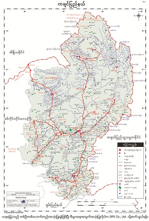
Kachin Mapကချင်မြေပုံ
To download the full and complete Kachin Map: ကချင်မြေပုံ အပြည့်အစုံကို ဒေါင်းလုဒ်ရယူရန်:
- Press Download. Download ကိုနှိပ်ပါ။
- Complete the form and press submit. Form ကိုဖြည့်စွက်ပြီး submit နှိပ်ပါ။
- You will receive the download link via email, sent to the email address you provided. သင်ပေးထားသော အီးမေးလ်လိပ်စာသို့ ဒေါင်းလုဒ်လင့်ခ်ကို ပေးပို့ပါမည်။