The Map Of Magway Regionမကွေးတိုင်းဒေသကြီး မြေပုံ
Magway Region is located in the central part of Myanmar, known for its petroleum production, dry zone agriculture, and historical heritage sites. မကွေးတိုင်းဒေသကြီးသည် မြန်မာနိုင်ငံအလယ်ပိုင်းတွင် တည်ရှိပြီး ရေနံထွက်ရှိမှု၊ အခြောက်ပိုင်း စိုက်ပျိုးရေးနှင့် သမိုင်းဝင်အမွေအနှစ်နေရာများဖြင့် ထင်ရှားသည်။
About Magway Region မကွေးတိုင်းဒေသကြီး အကြောင်း
Magway Region is bounded by Mandalay Region to the north, Bago Region to the east and south, Ayeyarwaddy Region to the south, and Rakhine State and Chin State to the west. It is often referred to as the "oil bowl" of Myanmar due to its significant oil fields. မကွေးတိုင်းဒေသကြီးသည် မြောက်ဘက်တွင် မန္တလေးတိုင်း၊ အရှေ့နှင့်တောင်ဘက်တွင် ပဲခူးတိုင်း၊ တောင်ဘက်တွင် ဧရာဝတီတိုင်း၊ အနောက်ဘက်တွင် ရခိုင်ပြည်နယ်နှင့် ချင်းပြည်နယ်တို့နှင့် နယ်နိမိတ်ချင်း ထိစပ်နေသည်။ ရေနံထွက်ရှိရာ ဒေသဖြစ်သောကြောင့် မြန်မာနိုင်ငံ၏ "ရေနံအိုးကြီး" ဟု တင်စားကြသည်။
The region features major ancient cities such as Sri Ksetra (near Pyay border) and Beikthano (Visnu City), which is a UNESCO World Heritage site showcasing early urban development in Myanmar. ယင်းဒေသတွင် ရှေးဟောင်းမြို့ပြများဖြစ်သော သရေခေတ္တရာ (နယ်စပ်အနီး) နှင့် မြန်မာနိုင်ငံ၏ ရှေးဦးမြို့ပြဖွံ့ဖြိုးမှုကို ဖော်ပြနေသည့် ယူနက်စကို ကမ္ဘာ့အမွေအနှစ်နေရာဖြစ်သော ဗိဿနိုး ရှေးဟောင်းမြို့တို့ တည်ရှိသည်။
3.9M+
Populationလူဦးရေ
Magway
Capital Cityမြို့တော်
25
Townshipsမြို့နယ်
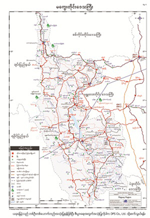
Magway Mapမကွေးမြေပုံ
To download the full and complete Magway Map: မကွေးမြေပုံ အပြည့်အစုံကို ဒေါင်းလုဒ်ရယူရန်:
- Press Download. Download ကိုနှိပ်ပါ။
- Complete the form and press submit. Form ကိုဖြည့်စွက်ပြီး submit နှိပ်ပါ။
- You will receive the download link via email, sent to the email address you provided. သင်ပေးထားသော အီးမေးလ်လိပ်စာသို့ ဒေါင်းလုဒ်လင့်ခ်ကို ပေးပို့ပါမည်။