The Map Of Naypyitawနေပြည်တော် မြေပုံ
Naypyitaw is the capital city and union territory of Myanmar, featuring wide modern highways, administrative ministries, and designated residential and hotel zones. နေပြည်တော်သည် မြန်မာနိုင်ငံ၏ မြို့တော်နှင့် ပြည်ထောင်စုနယ်မြေ ဖြစ်ပြီး ခေတ်မီကျယ်ဝန်းသော လမ်းမကြီးများ၊ အစိုးရဝန်ကြီးဌာနများနှင့် သီးသန့်ရပ်ကွက်၊ ဟိုတယ်ဇုန်များ ပါဝင်ဖွဲ့စည်းထားသည်။
About Naypyitaw နေပြည်တော် အကြောင်း
Naypyitaw Union Territory is centrally located in Myanmar, surrounded by Mandalay Region, Magway Region, and Bago Region. It serves as the administrative seat of the government and is divided into several townships such as Zabuthiri, Pyinmana, Ottarathiri, and Lewe. နေပြည်တော် ပြည်ထောင်စုနယ်မြေသည် မြန်မာနိုင်ငံအလယ်ပိုင်းတွင် တည်ရှိပြီး မန္တလေးတိုင်း၊ မကွေးတိုင်းနှင့် ပဲခူးတိုင်းတို့ဖြင့် ဝန်းရံလျက်ရှိသည်။ အစိုးရ၏ အုပ်ချုပ်ရေးရုံးစိုက်ရာ နေရာဖြစ်ပြီး ဇမ္ဗူသီရိ၊ ပုဗ္ဗသီရိ၊ဥတ္တရသီရိ၊ လယ်ဝေး စသည့် မြို့နယ်များဖြင့် ဖွဲ့စည်းထားသည်။
The city is designed with expansive zoning for government ministries, military headquarters, international convention centres, and prominent landmarks like the Uppatasanti Pagoda. မြို့ပြစီမံကိန်းအရ အစိုးရဝန်ကြီးဌာနများ၊ တပ်မတော်ရုံးချုပ်များ၊ နိုင်ငံတကာကွန်ဗင်းရှင်းစင်တာများနှင့် ဥပ္ပါတသန္တိစေတီတော် ကဲ့သို့သော ထင်ရှားသည့် အထိမ်းအမှတ်နေရာများဖြင့် ကျယ်ဝန်းစွာ တည်ဆောက်ထားသည်။
1.1M+
Populationလူဦးရေ
Capital
Union Territoryပြည်ထောင်စုနယ်မြေ
8
Townshipsမြို့နယ်
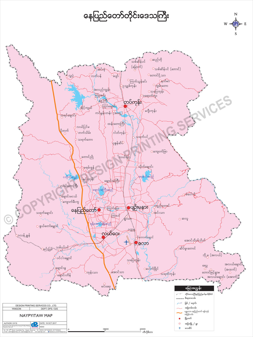
Naypyitaw Mapနေပြည်တော်မြေပုံ
To download the full and complete Naypyitaw Map: နေပြည်တော်မြေပုံ အပြည့်အစုံကို ဒေါင်းလုဒ်ရယူရန်:
- Press Download. Download ကိုနှိပ်ပါ။
- Complete the form and press submit. Form ကိုဖြည့်စွက်ပြီး submit နှိပ်ပါ။
- You will receive the download link via email, sent to the email address you provided. သင်ပေးထားသော အီးမေးလ်လိပ်စာသို့ ဒေါင်းလုဒ်လင့်ခ်ကို ပေးပို့ပါမည်။