The Map Of Sagaing Regionစစ်ကိုင်းတိုင်းဒေသကြီး မြေပုံ
Sagaing Region is located in the northwestern part of Myanmar, known for its religious significance, historical monuments, and diverse geographical terrain. စစ်ကိုင်းတိုင်းဒေသကြီးသည် မြန်မာနိုင်ငံ အနောက်မြောက်ဘက်တွင် တည်ရှိပြီး သာသနာရေးဆိုင်ရာ ထင်ရှားမှုများ၊ သမိုင်းဝင်အထိမ်းအမှတ်များနှင့် ကွဲပြားခြားနားသော မြေမျက်နှာသွင်ပြင်များဖြင့် ကျော်ကြားသည်။
About Sagaing Region စစ်ကိုင်းတိုင်းဒေသကြီး အကြောင်း
Sagaing Region is bordered by Nagaland and Manipur of India to the north and northwest, Kachin State, Shan State, and Mandalay Region to the east, Mandalay Region and Magway Region to the south, and Chin State and India to the west. Monywa and Sagaing are major cities within the region. စစ်ကိုင်းတိုင်းဒေသကြီးသည် မြောက်ဘက်နှင့် အနောက်မြောက်ဘက်တွင် အိန္ဒိနိုင်ငံ နာဂလန်းနှင့် မဏိပူရ်၊ အရှေ့ဘက်တွင် ကချင်ပြည်နယ်၊ ရှမ်းပြည်နယ်နှင့် မန္တလေးတိုင်း၊ တောင်ဘက်တွင် မန္တလေးတိုင်းနှင့် မကွေးတိုင်း၊ အနောက်ဘက်တွင် ချင်းပြည်နယ်နှင့် အိန္ဒိယနိုင်ငံတို့ဖြင့် နယ်နိမိတ်ချင်း ထိစပ်လျက်ရှိသည်။ မုံရွာနှင့် စစ်ကိုင်းမြို့တို့သည် ဒေသတွင်း အဓိကမြို့ကြီးများ ဖြစ်ကြသည်။
The region is rich in natural resources, ancient pagodas, and historical sites such as the ancient royal capital of Ava (across the river), Mingun, and the Hanthawaddy and Bodhi Tahtaung areas in Monywa. သဘာဝသယံဇာတ ကြွယ်ဝပြီး ရှေးဟောင်းဘုရားပုထိုးများနှင့် ရှေးဟောင်းမြို့တော် အင်းဝ (မြစ်တစ်ဖက်ကမ်း)၊ မင်းကွန်း၊ မုံရွာရှိ ဗောဓိထောင် စသည့် သမိုင်းဝင်နေရာများ တည်ရှိရာ ဒေသတစ်ခု ဖြစ်သည်။
5.3M+
Populationလူဦးရေ
Sagaing
Capital Cityမြို့တော်
37
Townshipsမြို့နယ်
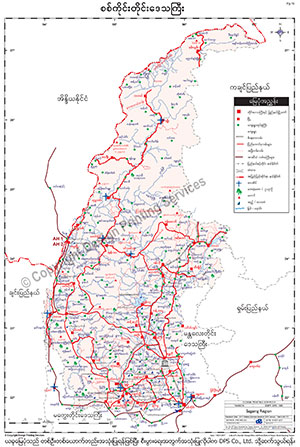
Sagaing Mapစစ်ကိုင်းမြေပုံ
To download the full and complete Sagaing Map: စစ်ကိုင်းမြေပုံ အပြည့်အစုံကို ဒေါင်းလုဒ်ရယူရန်:
- Press Download. Download ကိုနှိပ်ပါ။
- Complete the form and press submit. Form ကိုဖြည့်စွက်ပြီး submit နှိပ်ပါ။
- You will receive the download link via email, sent to the email address you provided. သင်ပေးထားသော အီးမေးလ်လိပ်စာသို့ ဒေါင်းလုဒ်လင့်ခ်ကို ပေးပို့ပါမည်။