The Map Of Shan Stateရှမ်းပြည်နယ် မြေပုံ
Shan State is the largest state in Myanmar by area, featuring diverse landscapes, multiple ethnic groups, and Taunggyi as its capital city. ရှမ်းပြည်နယ်သည် မြန်မာနိုင်ငံတွင် ဧရိယာအကျယ်အဝန်းအကြီးဆုံး ပြည်နယ်ဖြစ်ပြီး မတူကွဲပြားသော မြေမျက်နှာသွင်ပြင်များ၊ တိုင်းရင်းသားလူမျိုးစုများနှင့် တောင်ကြီးမြို့ကို မြို့တော်အဖြစ် တည်ရှိသည်။
About Shan State ရှမ်းပြည်နယ် အကြောင်း
Shan State shares borders with China to the north, Laos to the east, and Thailand to the south, as well as several Myanmar regions and states to the west. It is renowned for its high plateaus, mountains, and cultural heritage. ရှမ်းပြည်နယ်သည် မြောက်ဘက်တွင် တရုတ်နိုင်ငံ၊ အရှေ့ဘက်တွင် လาวနိုင်ငံ၊ တောင်ဘက်တွင် ထိုင်းနိုင်ငံတို့နှင့် နယ်နိမိတ်ချင်း ထိစပ်နေပြီး ကုန်းပြင်မြင့်များ၊ တောင်တန်းများနှင့် ယဉ်ကျေးမှုအမွေအနှစ်များဖြင့် ထင်ရှားသည်။
Shan State is home to various ethnic groups such as Shan, Pa-O, Danu, Palaung, Intha, Kachin, Kokang, and Wa. ရှမ်းပြည်နယ်တွင် ရှမ်း၊ ပအိုဝ်း၊ ဓနု၊ ပလောင်၊ အင်းသား၊ ကချင်၊ ကိုးကန့်နှင့် ဝ စသည့် တိုင်းရင်းသားလူမျိုးစုများ မှီတင်းနေထိုင်ကြသည်။
6M+
Populationလူဦးရေ
Taunggyi
Capital Cityမြို့တော်
55
Townshipsမြို့နယ်
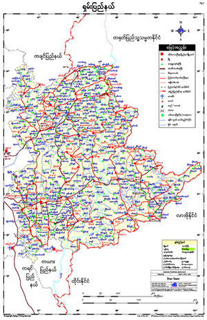
Shan Mapရှမ်းမြေပုံ
To download the full and complete Shan Map: ရှမ်းမြေပုံ အပြည့်အစုံကို ဒေါင်းလုဒ်ရယူရန်:
- Press Download. Download ကိုနှိပ်ပါ။
- Complete the form and press submit. Form ကိုဖြည့်စွက်ပြီး submit နှိပ်ပါ။
- You will receive the download link via email, sent to the email address you provided. သင်ပေးထားသော အီးမေးလ်လိပ်စာသို့ ဒေါင်းလုဒ်လင့်ခ်ကို ပေးပို့ပါမည်။