Latest News: 2026 Yangon City Map is now available! Order now with promo price 35,000mmk. Special Offer: Use code DPS2026 to get 10% Discount!
Mon State city map

The Map of Mawlamyaing

Explore Mawlamyaing, the capital of Mon State and a historic port city on the Thanlwin River.

DPS Map of Mawlamyaing
Mon StateState capital
MoulmeinFormer English name
1826–1862Capital of British Lower Burma
875 ADKyaikthanlan Pagoda origin
About Mawlamyaing

A historic river and port city

The city has long connected Mon heritage, river trade and colonial history.

Mawlamyaing, formerly known as Moulmein, is the capital of Mon State, Myanmar. It served as the administrative capital of British Lower Burma and became a thriving teak port from 1826 to 1862. Its strategic position made it the first British seaport in Southeast Asia, while the timber trade helped the city grow and prosper.

Originally a Mon city, Mawlamyaing has a long history shaped by conflict, trade and cultural exchange. Its best-known landmark is Kyaikthanlan Pagoda, traditionally dated to 875 AD. The city also retains a number of colonial-era buildings alongside modern development.
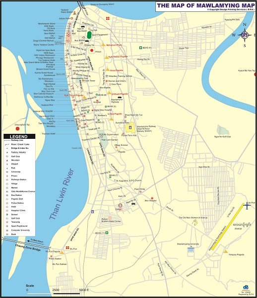
DPS city map

Mawlamyaing Map

Select the map image to view it at a larger size.

The Map of MawlamyaingDPS Map city reference
Click to enlarge +
Free map download

Download the complete Mawlamyaing map

Use the current DPS download page to request the full map safely.

How to download

  1. 1Open the DPS Map Download page.
  2. 2Choose the Mawlamyaing or Mon map option and complete the required information with a correct email address.
  3. 3Submit the form and check your inbox or spam folder for the verification or download message.
Go to Map Download