⌖
Field Survey & Data Collection
GPS points, house numbers, roads, lanes, POIs, AOIs, retail outlets and ground observations.
From field surveys and address databases to utility networks, retail intelligence and drone mapping, DPS turns location data into decisions.
A geographic information system gathers, manages and analyzes location data. It combines different information layers and presents relationships through maps, dashboards and 3D scenes.
DPS has worked with GIS and map-data warehousing from its earliest projects. Our teams combine ground control, GPS surveys, satellite imagery and local field knowledge to build practical datasets for Myanmar.
Choose a complete end-to-end service or ask DPS to support one part of your existing workflow.
GPS points, house numbers, roads, lanes, POIs, AOIs, retail outlets and ground observations.
Data models, layer planning, cleanup, conversion, geocoding and customized spatial databases.
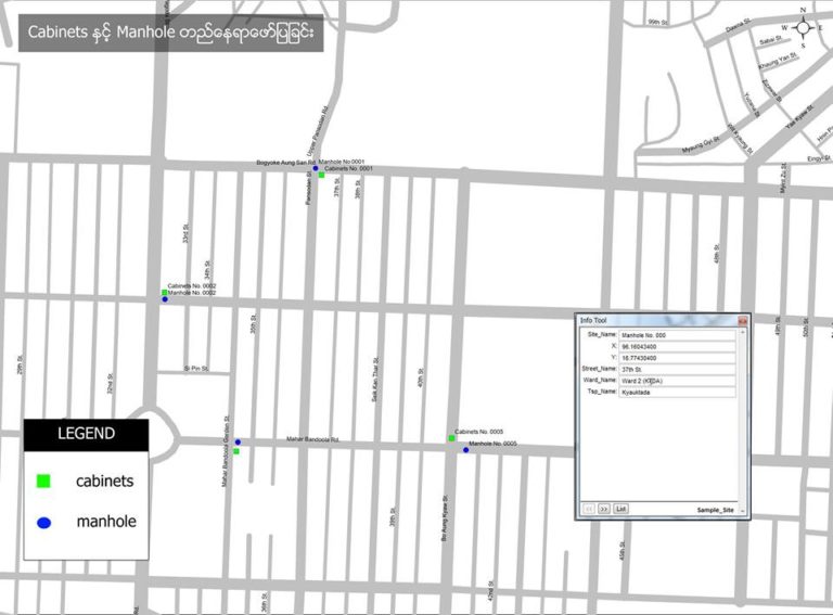
Network routes, fiber layouts, manholes, cabinets, junctions and maintenance-ready asset records.
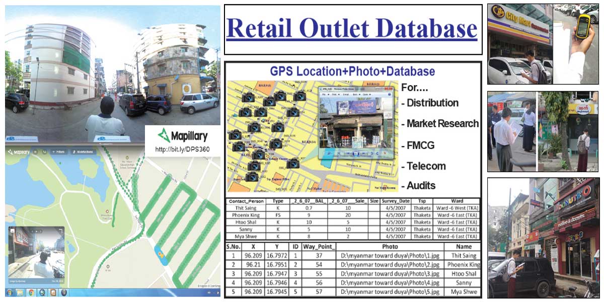
Outlet mapping, service-area analysis, competitor studies and route-planning datasets.
Current aerial imagery, site plans, terrain models, elevation analysis and contour maps.
Interactive maps, project dashboards, thematic maps and decision-ready presentations.
DPS datasets support navigation, planning, logistics, banking, insurance, telecom and public-service projects.
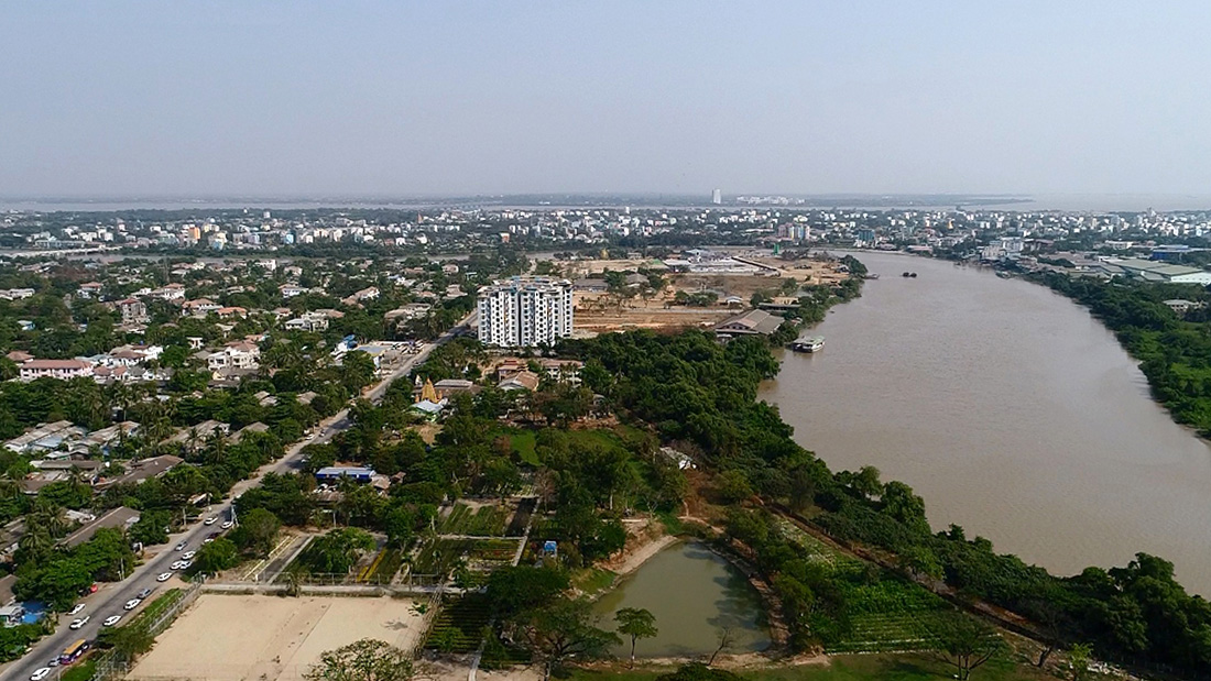
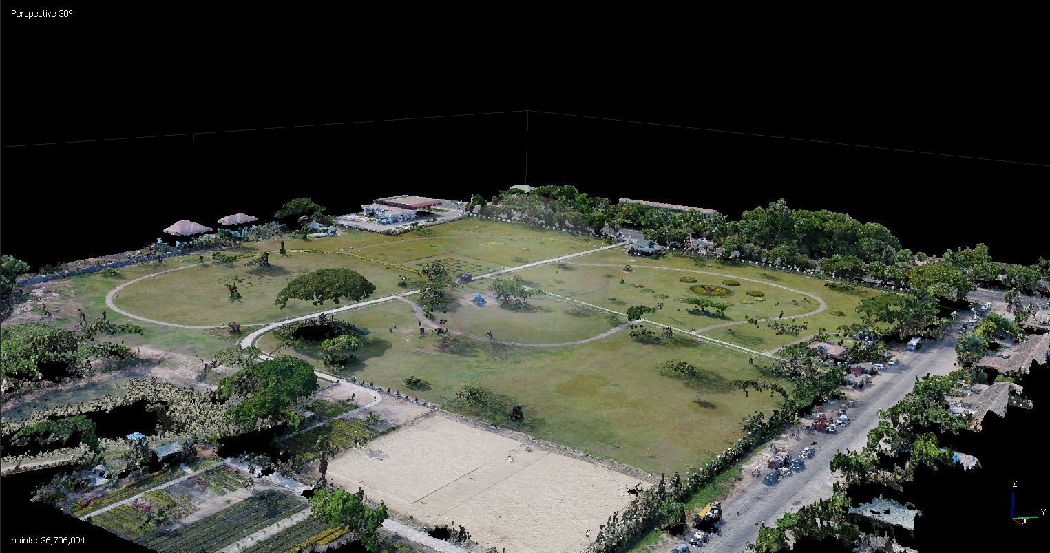
High-resolution aerial surveys help landowners, planners and engineering teams create site plans and make informed decisions before construction.
The detailed information retained from the previous DPS GIS page is organized below for easier reading.
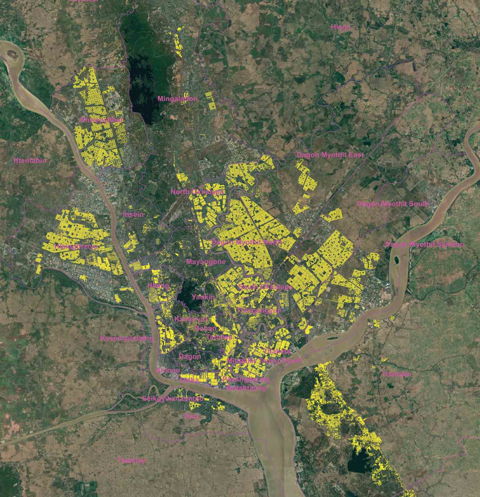
Address Point coverage used for navigation and location-based services.
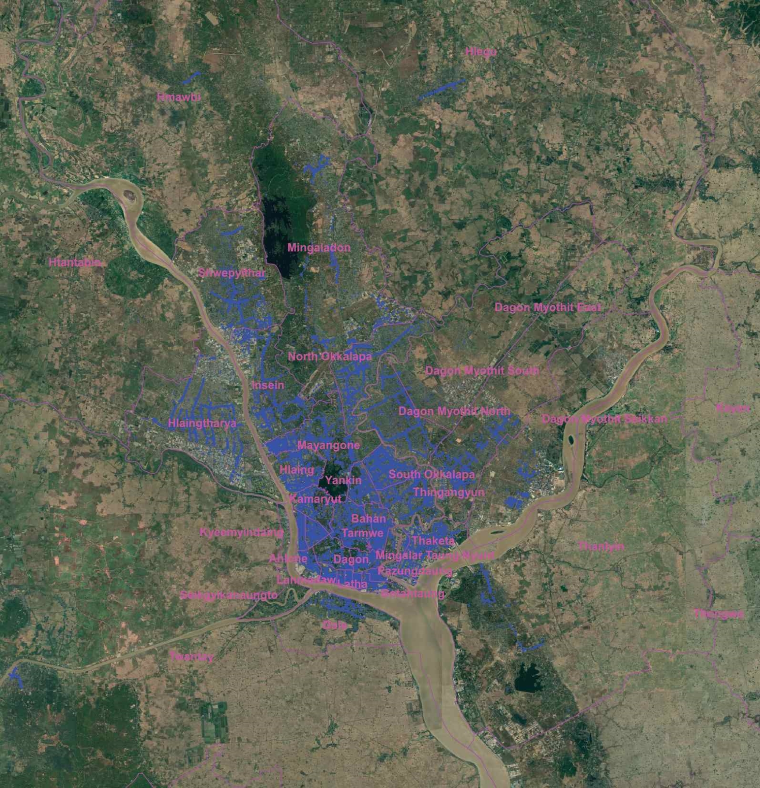
Points of Interest coverage for retail, distribution, banking, insurance and city-guide applications.
DPS has been involved in map making and GIS data warehousing from day one. Its first satellite-map project began in 1998, when this imagery was largely reserved for military and oil-and-gas exploration in Myanmar. DPS then established Ground Control Points with Trimble Pro XR survey GPS equipment and completed Yangon streets in UTM in 1998. Early major customers included the US Government and MEGA Life Sciences.
Today, DPS GIS data includes the Myanmar road network, village points, Address Points (AP) and Points of Interest (POI). APs support ride-hailing and navigation services such as Grab and TomTom. DPS records include approximately 300,000 APs for Yangon, Mandalay and other major cities, together with around 60,000 POIs with rich attributes for distribution, retail, banking and insurance applications. DPS continues collecting detailed attributes for retail, navigation and future autonomous-vehicle use.
Current activity: Since 2018, DPS has collected POIs for Yangon and Naypyidaw and APs for Yangon, Mandalay and Naypyidaw, including data primarily used for Grab Taxi.
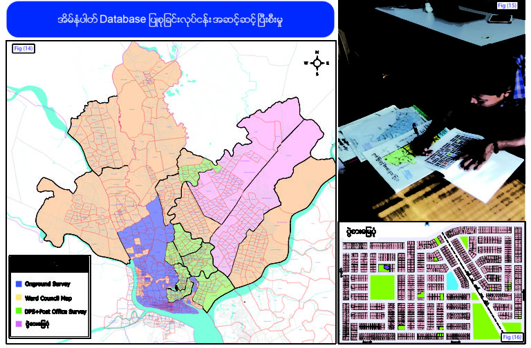
The 2021 update extends to Yangon Region boundaries. The address database includes house numbers and is designed to exceed commonly available online coverage.
POI content includes: 2,000+ bus stops, 370+ government offices, 340+ schools, factories, banks, condominiums, hotels, restaurants, monasteries, religious buildings, pagodas, railway stations, supermarkets, offices, hospitals, clinics, churches, gas stations, stadiums, parks and embassies.
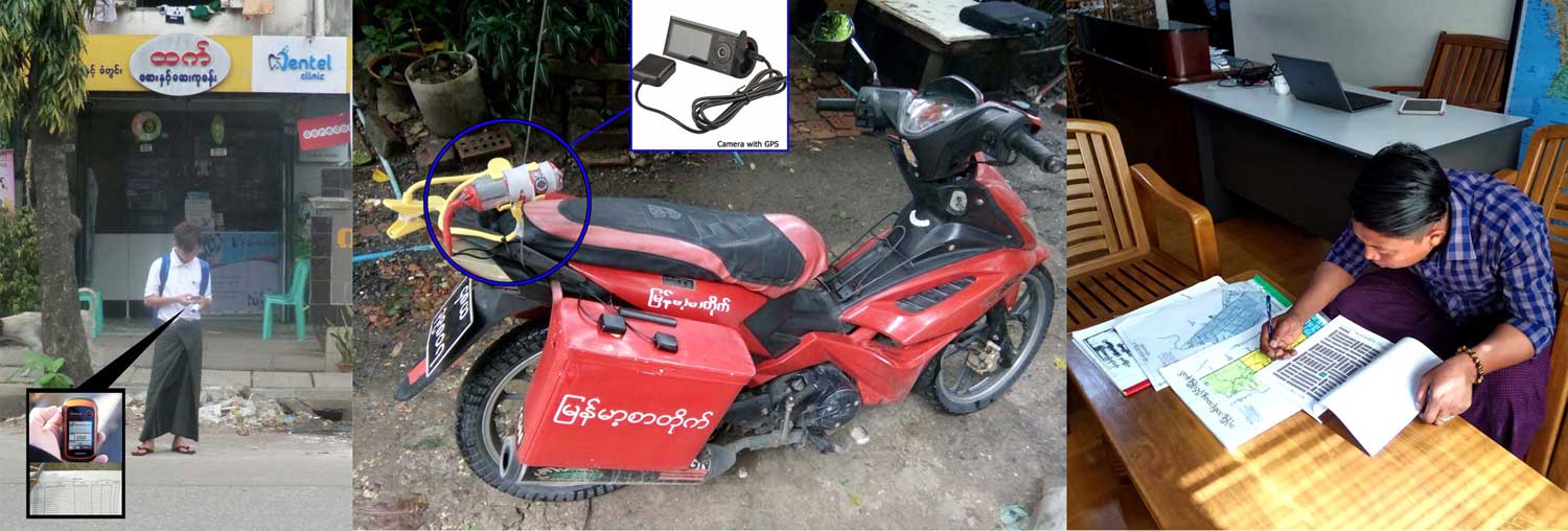
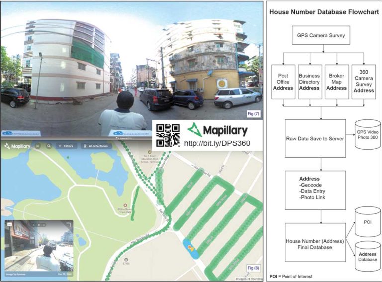
House-number survey method: GPS cameras are installed on motorbikes and bicycles. At each property, GPS points and photographs are captured together with the relevant address details.
DPS uses high-quality drone aerial photography to create current site imagery, site plans, Digital Elevation Models (DEM) and contour maps. The resulting information supports decisions about building placement, drainage, planting, terrain and flood conditions.
The legacy portfolio also includes sample printed drone aerial photography, the Mergui Archipelago Island Finder, Myanmar GIS, Yangon GIS and Yangon City Digital Map projects.
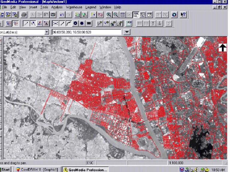
The Yangon City Digital Map is a GIS originally developed with Intergraph GeoMedia Professional. Its base map was digitized from IRS Panchromatic satellite imagery at 5.8-metre resolution and calibrated with Trimble Pro XR GPS ground references.
| Main datasets | Available formats | Price and licence |
|---|---|---|
| Street map and street names Landmarks and moderated places Township demographics (33 townships plus Thanlyin) Banks, healthcare, government offices, hotels and restaurants Customized retail-shop surveys | DXF ESRI Shapefile / ArcInfo MapInfo / MIF GeoMedia | Prices vary by category and required layers. Contact DPS for a project-specific quotation. |
Legacy pricing: These figures are retained from the old page for reference and should be confirmed with DPS before ordering.
| GIS Map | Legacy price | Paper map | Legacy price |
|---|---|---|---|
| DPS-GIS-01 | 7,000 USD | Myanmar Guide Map | 10 USD |
| DPS-GIS-02 | 3,500 USD | Tourist Maps | 7 USD |
| DPS-GIS-03_MmTsp | 5,000 USD | Yangon Map Wall Sheet | 10 USD |
| DPS-GIS-04_Mandalay | 5,000 USD | Yangon Street Directory | 29 USD |
| DPS-GIS-05_Bagan | 5,000 USD | — | — |
| DPS-GIS-10_Naypyidaw | 5,000 USD | — | — |
Create a customized map using selected data layers from the legacy catalogue:
| DPS Code | SNO | Data description | File / entries | Geometry and attributes |
|---|---|---|---|---|
| DPSGIS01 | 1 | Yangon City Complete Set (08) | — | — |
| 1.1 | Yangon Streets | Yan_St_UTM_08 · 23,210 entries | Line · st.name_E, st.name_M, township, condition, width | |
| 1.2 | Yangon Township Boundary | Yan_Township_boundary · 33 entries | Area | |
| 1.3 | Yangon Water Body | Yan_water | Area | |
| 1.4 | Yangon Places of Interest | Yan_places_08 | Point / Area | |
| 1.5 | Street Directory Book Page Grid | MOYgrid | Area | |
| DPSGIS02 | 2 | Yangon City Major Roads Set | — | — |
| 2.1 | Yangon Major Streets only | — | Line | |
| 2.2 | Yangon Township Boundary | Yan_Township_boundary · 33 | Area | |
| 2.3 | Yangon Water Body | Yan_water | Area / Line | |
| 2.4 | Selected Yangon Places of Interest | — | Point / Area | |
| DPSGIS03 | 3 | Myanmar Townships Set | — | — |
| 3.1 | Myanmar International Border | — | Line | |
| 3.2 | Myanmar Town Points | 926 entries | Point | |
| 3.3 | Myanmar Township Areas | 325 entries | Area · Name, MIMUcode, StateDiv, Othername, Mname | |
| 3.4 | Myanmar Major Rivers | — | Line | |
| 3.5 | Railway | — | Line | |
| 3.6 | Myanmar Major Road | 175 entries | Line · Name | |
| 3.7 | States and Divisions | 14 entries | Area | |
| DPSGIS04 | 4 | Mandalay Dataset | Streets 2008, township boundaries, water body and POIs | Line / Area / Point |
| DPSGIS05 | 5 | Bagan Dataset | Streets, township boundaries, water body and POIs | Mixed |
| DPSGIS06 | 6 | Bagan Pagodas | — | — |
| DPSGIS07 | 7 | Taunggyi | — | — |
| DPSGIS08 | 8 | Mawlamyaing | — | — |
| DPSGIS09 | 9 | Kawthaung | — | — |
| DPSGIS10 | 10 | Naypyidaw | NPD Streets 2007, township boundary, water body and POIs | Mixed |
| DPSGIS11 | 11 | Myanmar Airports and Myanmar Drainage | — | — |
| DPSGIS12 | 12 | Countrywide roads, tracks and trails | — | — |
| DPSGIS13 | 13 | Myeik | — | — |
| DPSGIS14 | 14 | Mergui Detail (Planned) | Islands, township population areas, town points, dive sites, villages/tourist attractions, rubber and palm-oil plantations, hydropower | Mixed |
| DPSGIS15 | 15 | Bago | — | — |
| DPSGIS16 | 16 | Pathein | — | — |
| DPSGIS17 | 17 | Ayeyarwady Detail – Nargis (Planned) | — | — |
Delivery method stated on the legacy page: after payment is received, the file is sent by email. The page also listed FTP as delivery media.
| Company | Design Printing Services |
|---|---|
| Legacy address | 165/167, Room 4, 1st Floor, 35th Street, Kyauktada Township, Yangon, Myanmar |
| Point of contact | Aye Min Oo (Mr.) |
| Legacy telephone/fax | 951-245230 |
| Legacy catalogue email | [email protected] |
| Data title | Myanmar Countrywide and Yangon City Digital Mapsets |
| Scale | Myanmar Countrywide dataset: 1:2,000,000 · Yangon City dataset: 1:30,000 |
| Data layers | Countrywide: town points and names, township areas, rivers and highways. Yangon City: townships, banks, healthcare centres, government offices, hotels, restaurants, streets, landmarks and POIs. |
| Data format | ESRI Shapefile, MapInfo |
| Projection | Latitude / Longitude (Decimal Degrees) |
| Datum and ellipsoid | WGS 84 |
| Primary language | English |
| Metadata and documentation | All available metadata and technical documentation; data dictionary: Yes; database design: Yes; documentation language: English. |
| Quality requirement | Datasets are intended to be seamlessly integrated and topologically correct. |
| Licence type | Client licence; quantity based on seats/users |
| Delivery media | FTP / email, according to the legacy information |
The previous page presented a step-by-step house-number-data demonstration, shop and retail-outlet material, a retail video, high-condominium counting, 360° photographs and interactive competitor-location examples.
Order DPS GIS Data Myanmar in MapInfo or ArcView (ESRI Shapefile) format. Tell DPS which geographic area, data layers, file format and number of licence seats you require.
The old page referred to GIS data on CD and legacy prices. Current availability, media, licensing and prices should be confirmed before purchase.
Enquire for GIS MapTell us your project area, required layers and intended use. DPS will prepare a suitable approach and quotation.