Inle Lake & Floating Villages
Picturesque 900m highland lake known for leg-rowing Intha fishermen, floating tomato gardens, and stilt lodges.
Shan State is the largest state in Myanmar by area, covering almost a quarter of the country, renowned for its cool climate, diverse ethnic peoples, agricultural valleys, and highland lakes.
Shan State borders China to the north, Laos to the east, and Thailand to the south. It is divided administratively into South, North, and East Shan State, spanning 55 townships and several self-administered zones (Wa, Pa'O, Danu, Palaung, Kokang).
Taunggyi is the state capital celebrated for the Tazaungdaing Balloon Festival. The state also encompasses global tourist destinations like Inle Lake, Kalaw, Pindaya Caves, and Kengtung.
Population
Capital City
Townships
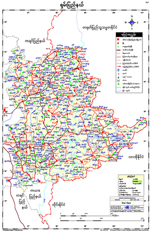
To download the full and complete Shan State Map:
Highland lakes, caves and cultural hubs across Shan State.
Picturesque 900m highland lake known for leg-rowing Intha fishermen, floating tomato gardens, and stilt lodges.
Sacred cave complex winding deep into limestone ridge housing over 8,000 historic Buddha statues.
Colonial-era pine mountain town famous for scenic multi-day hiking trails to Inle Lake.