Sagaing Hills & Sun U Ponnya Shin
Sacred meditation ridge dotted with hundreds of white and golden stupas overlooking the Ayeyarwaddy River.
Sagaing Region is the second largest region in Myanmar, spanning the Chindwin and Ayeyarwaddy river valleys, celebrated for meditation hills, copper mines, and ancient heritage.
Sagaing Region borders India (Nagaland and Manipur) and Kachin State to the north, Shan State to the east, Mandalay and Magway to the south, and Chin State to the west. It contains the fertile Chindwin basin and rich mineral reserves.
Sagaing city is Myanmar's monastic spiritual capital with over 600 monasteries and nunneries along Sagaing Hills. Other economic and heritage hubs include Monywa (famed for Thanboddhay Pagoda), Shwebo, and Mingun.
Population
Capital City
Townships
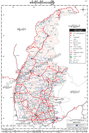
To download the full and complete Sagaing Region Map:
Monastic sanctuaries and massive monuments across Sagaing.
Sacred meditation ridge dotted with hundreds of white and golden stupas overlooking the Ayeyarwaddy River.
World's second largest ringing bell (90 tons) and the monumental unfinished brick stupa of King Bodawpaya.
Vibrant temple complex with over 580,000 Buddha images and the world's second tallest standing Buddha statue (116m).